Not Quite the World Traveler: Discover Places that I Love:
Parowan Gap, UT - May 20, 2012
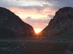
Sunset at Parowan Gap
The
sun sinks ever so slowly toward the narrow volcanic cleft in the rocks,
shooting daggers of light and shadow across the basin, touching upon
the rock cairns nestled in
the prairie grass and sagebrush. The face of Tobats, The "Overseer" -
an easily distinguishable profile of a face, overlooks the gap as
thousands of years of human history recede from view while the light
diminishes on the petroglyphs carved in the rock walls of the narrow
gap. Here the blend of ancient and modern finds an easy rhythm in the
calls of the birds from the sage, the cry of eagles nesting in the
bluffs and the hum of tires on the asphalt. And we are here on a
particularly important day - the first annular solar eclipse visible in
this part of the country since 1994, a good 18 years past.
While
already an important historically significant site, contemporary to the
raising of the monoliths at Stonehenge, and used in a fashion to mark
the passage of time and serve as a cosmic calendar for solar alignments
of the sun, moon, and other planetary bodies such as the track of the
planet Venus across the night
sky, our visit on May 20, 2012 was precipitated by the ideal viewing
conditions to observe the solar eclipse. While many mysteries surround
the significance of many of the thousands of petroglyphs carved into the
faces of the rocks here, several have been remarkable in their ability
to predict the precise location of the sun and moon throughout the year.
Also present within the Gap are two small caves, both inscribed with
petroglyphs, and containing remnants of human inhabitants such as flint
arrowheads, pottery pieces and evidence of soot from fires left on the
ceilings. (And also a few bats!) These artifacts have been carbon dated
back to 12,000 years ago. Such an enormity of human existence cataloged
and recorded in one place boggles the mind.
As for more recent history, as the Parowan Gap website explains:
When the first Mormon Pioneers came there in
1849, Chief Wakara, a widely revered and greatly respected Paiute
tribal leader, told them that Parowan Gap was "God's Own House."
Recent research and observation is making both the scientist and
casual visitor take this statement very seriously. There are
solar and lunar events that happen there which were created by no
human intervention. Phenomena occur which create a natural
calendric structuring of the year's times and seasons with a kind
of "Primal Logic of Nature". The pre-Columbian Fremont Peoples
of the Parowan Valley noticed these yearly events and recorded
them by date number and in many symbolic petroglyphic
inscriptions. (www.parowangap.org)
Perhaps
one of the most remarkable and memorable of the glyphs is the large
aptly-named "Zipper Glyph" with its 180 tic-mark "teeth". Only beginning
to be studied scientifically in depth starting in 1990, many of the
glyphs were noted to contain lines and dots, tics and and repeating
patterns. In studying the Zipper Glyph, it revealed itself to be a map
representing the geography of the Gap itself and the surround region,
with the tic-marks representing solar alignment positions, and rock
cairns spreading into the basin marking the phases of the year for
equinoxes, solstices and cross-quarters, or the dates between the
equinox and solstices. Deliberately and carefully marked, the large
Zipper Glyph is marking the time in observable, categorized segments.
As
the website continues to explain "The angle between the arms of the Zipper Glyph closely approximated
the horizontal traverse of the sunsets between the solstices.
Consequently, we had a glyph of considerable
size and detail which contains both the angular traverse of the
sun and the number of days it takes to make that
traverse. Furthermore the cairn system
divides the solar traverse into four equal periods which matches
the distribution of counts on the Zipper Glyph." After deciphering the
purpose of the Zipper Glyph being used as a solar calendar, it only
followed that there would be a corresponding lunar calendar, and there
was. It was located just around the bend in the rocks, facing the
opposite direction to coordinate with moonrise.

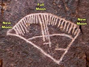
Similar
to the Zipper Glyph, the lunar calendar glyph shows lines which
indicate the phases of the moon, and even dividing the lunar cycles into
29 day cycles (months) each containing 4 divisions of "weeks", and even
accounting for the partial lunar phase completing the year. Of
particular interest to me were the geologic formations through which are
visible the sun and moon
between the lineup of particular gaps in the rocks, including The
Overseer "swallowing" the sun through his mouth to herald the coming of
winter and spitting it back out again indicating the turning of the
seasons back to spring with re-giving light back to the earth. Another
small shaft between the rocks documents the 19 year extreme southernmost
rise of the full moon, through which gap the moonrise will appear.
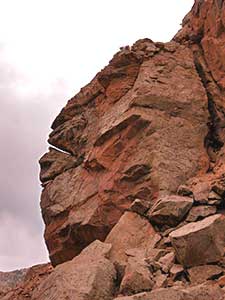 The face of The Overseer
While
many legends and stories surround the Parowan Gap, certain irrefutable
evidence of past history is inscribed on the walls, such as the Spanish
waybill dated 1839 and marked with a skull, crossbones and a cross, and
other dates of 1882 and 1887 of settlers and pioneers passing through
that left their marks. Unfortunately, modern graffiti including
spraypaint and initials
inside a heart and names carved into the sandstone spoil some
of the petroglyphs located here, and sadly some very important inscribed boulders were destroyed in
the forming of the road through the narrow gap in the 1960s, eradicating perhaps as
much as half the total petroglyphs on site, a tragedy of epic proportions.
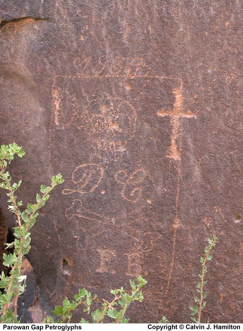
Spanish Waybill indicating the location of buried booty hidden from the slave revolts and uprisings of the local people captured and forced to work in the mines by the Spanish. These waybills were to disclose the locations of the mines or buried precious metals.
Archaeological evidence has shown that the Parowan Freemont peoples lived in this Parowan
valley, near the shores of the shallow salt lake (now dry) located
approximately five miles from the Gap. Used as a passageway by
ancient peoples, other culture's artifacts have also been located on the site
as well. Whether serving as a ceremonial gathering place, a hunting
rendezvous, or simply a way to mark their passing, the petroglyphs here weree carved as a ritualistic set of drawings
acknowledging the ancestors, their cultural legends and stories, an
accounting for the passage of seasons, marking of solstices and
equinoxes and a guiding plot map for other celestial bodies. Parowan Gap
remains a place imbued with mystery. The footsteps across the ages of
ancient peoples who stood in the same place where we now stand,
watching the sun slowly making its way down the walls of the gap. Perhaps then even observed another eclipse with all the other-worldly
majesty of such a remarkable event.
The
moon creeps closer to totality in the eclipse, and the sunlight dims to an odd
silvery-gray, the temperature noticeable cools, adding to the goosebumps
coursing my skin. The night birds begin their calls, and the moon
stands poised to overtake the last edge of sun as the crowd gathers in
breathless
anticipation. The moon takes over the fiery orb, shooting a flare outwards as a
Ring of Fire forms around the sun. The crowd whoops and hollers,
cat-calls and howls to the remarkable joining of the moon and sun in the
heavens, a pop-top cracks open in celebration, and wondering eyes take
in the spectacle for a few precious moments as the alignment of Earth,
Moon and Sun form an awe-inspiring moment. Interlaced fingers cast
crescent-shaped shadows as the Moon continues its journey, the "horns of
the bull" reforming and the light returning to its accustomed golden
glow as it sinks ever toward the waiting horizon.
And
finally, to close our adventure through time (and space), here is one
of the local legends of "Rush Lake" - the salt lake located close to
Parowan Gap.
The Rush Lake Legend
A Pahute Indian named "Narro-gwe-nap" or Keeper of the Tales
related the following legend to William R. Palmer (1877-1960)
who was an advisor and advocate to the Cedar City, Utah Pahute
Indian tribe.
In the early days, Rush Lake, Utah was a major travel route,
watering hole and campground to the Indians. The lake
was maintained by a spring that flowed from the point of the
black hill. In recent years, Rush Lake has dried up - no
doubtedly due to the lowering of ground water by wells in the
area.
As the Legend goes, the Indian Oonuput (That
one) killed Shinob (The god of love) at Rush Lake. This caused
Oonuput great shame and disgrace. The chief god Tobats swore to
kill Oonuput.
|
|
|
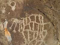
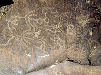
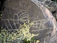
| Petroglyphs at Rush Lake |
Several days later as Tobats was inspecting the valley below, he
saw Oonuput wriggling through the brush trying to sneak in for
water. When Oonuput reached the lake and started drinking, Tobats
shot him through the back with an arrow. Oonuput died and turned
to stone.
William R. Palmer recalled that when he was a boy, he remembered
seeing a large stone in the shape of a man with a hole in its
back, lying at the water's edge. The stone was later broken up
and placed into the rock fence next to the lake.
After Oonuput was killed, a great darkness fell over the land.
It was so dark that fires could not be seen. There was great fear and
mourning among the people. During this time, the Indians began
wandering off in different directions getting themselves lost in
the darkness. Tobats went to the top of the hill and cried down
to the people telling them to stay in one place, grasp each
other's hands, and to gather into a group. He then told them to
come up to the top of the hill and make a circle around him.
In traveling up the hill, the Indians formed a trail that according to
Palmer was still there during his lifetime.
After the people were gathered, Tobats took his quiver of arrows
and began shooting them into the sky to see if the darkness could
be penetrated. The arrows were made with feathers from different
types of birds. After several attempts, Tobats picked up an arrow
with Flicker feathers on it. The arrow pierced the sky and opened
a small hole of light. When the arrow returned the feathers were
streaked with red. Tobats then used an arrow with Magpie
feathers. The arrow penetrated the darkness and light appeared.
Upon returning, the Magpie feathers were streaked with white.
Tobats called the Flicker bird to him. (At that time the Flicker
bird had no red.) Tobats told the bird that from this time forth
it would be streaked with red in honor of what it did. He then
called the Magpie bird to him, which at that time didn't have
white, and told the Magpie that it would be streaked with white
in honor of what it did. These two birds were sacred to the
Indians. (http://www.scienceviews.com/indian/rushlake.html)
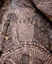
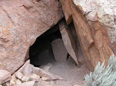
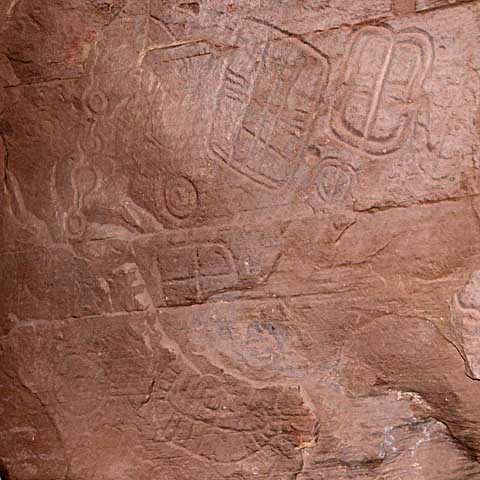
Petroglyphs showing the lines/dots pattern so common here. Entrance to the larger cave and a view of the petroglyphs carved inside.
Information, photos and more courtesy www.parowangap.org, http://www.scienceviews.com/indian/rushlake.html, http://www.scienceviews.com/photo/library/SIA1501.html (please see photo copyright information for Calvin J. Hamilton available at http://www.scienceviews.com/copyright.html)
and various images found on Google search - available on the web
(Regrettably not noted as this was originally to be for personal use only).
No comments:
Post a Comment